Wednesday, October 29, 2014

Tools for Evaluating Scholarly Journals

September, 24, 2014.
Bonnie Swoger, of Scientific American, has written an interesting blog post about the importance of evaluating material and some resources which make that task easier like JournalGuide, Google Metrics, etc.

"Of course, none of these tools replaces thoughtful evaluation. In order to use any of them effectively, you need to understand how they compile (or calculate) their information, and how that effects your purpose for that information."

To read the full post, click here.

Tuesday, October 28, 2014

World Heritage Ohio


World Heritage Ohio

"Several sites in Ohio are poised to join the extremely prestigious UNESCO World Heritage List, with more than 1000 other properties around the globe, including the Pyramids of Giza, the Great Wall of China, Australia's Great Barrier Reef, and Stonehenge. World Heritage inscription is based on stringent criteria and signifies outstanding universal value to humanity. Making the list helps ensure a site's permanent preservation, enhanced understanding, deeper appreciation, and increased tourism... Three nominations in Ohio are among 13 currently on the "US Tentative List" from which nominees will be drawn to go forward for inscription in the coming years."

Nominations

Reconstruction of the Newark Earthworks. Image Courtesy of the Ancient Ohio Trail.
Reconstruction of the Newark Earthworks.
Image Courtesy of the Ancient Ohio Trail.
"The Hopewell Ceremonial Earthworks share certain characteristics with other monumental sites built substantially from earth, such as Poverty Point, Cahokia Mounds, Effigy Mounds National Monument, Amazonian geoglyphs, Stonehenge, Avebury and Associated sites, but they are unique in their combination of vast scale, geometrical precision, incorporation of astronomical alignments, and broad geographic distribution. To have accomplished this with a predominantly hunting and gathering economy only supplemented by a suite of locally domesticated plants and with a fundamentally egalitarian society is unprecedented in world history.

The repetition of monumental earthwork forms across a large area, built to a similar scale, using a common unit of measure, and incorporating a similar series of astronomical alignments into that architecture, demonstrates a level of integration between otherwise disparate cultural groups that is unexpected and unprecedented for societies without more complex social organizations. This cultural integration was reinforced by an interregional network of raw material acquisition and craft production emphasizing a shared iconography. These earthworks, as a set, bear witness to a remarkable non-urban, non-hierarchical civilization that persisted for three to four centuries and exerted an influence that extended across much of eastern North America.

These Ancient Ohio monuments are the largest earthworks in the world that are not fortifications or defensive structures. Together these earthwork sites present the climax of the Woodland Period cultures of North America. Their extraordinary size, beauty, and precision make them outstanding examples of architectural form, landscape design, and human creative genius, worthy of inscription on the UNESCO World Heritage List."


"Serpent Mound, in Adams County, is the largest documented surviving example of a prehistoric effigy mound in the world.   It is a sinuous earthen embankment 411 meters long, including an oval embankment at one end, which has been interpreted variously as the serpent's eye, part of its head, or a secondary object, such as an egg, grasped in the serpent's open jaws.  The effigy ranges from 1.2 to 1.5 meters  in height and from 6 to 7.6 meters in width.  Radiocarbon dates obtained from samples from the effigy, combined with stylistic analyses of the iconography, indicate Serpent Mound was built by the Fort Ancient Culture about the year 1120 CE.  This state memorial also preserves three Native American burial mounds as well as evidence of contemporary habitation sites. "


Process
How it Works


What We've Done So Far
  • 2014 "The Steering Committee is currently at work on the next major component of the nomination, documents about the future on-going management of the sites – both individual site Management Plans, and a coordinated approach to the broader planning and development issues in the local communities that ICOMOS and UNESCO will expect to see, and that will be impacted by the anticipated increased tourist visitation at the sites."
  • 2013 Draft of Outstanding Universal Value, Draft of Comparative Analysis, Draft of Authenticity and Integrity, Experts Workshop
  • 2012 Steering Committee Formation
  • 2011 Conference Tour
  • 2009 Inclusion on the US Tentative List (2008) focused efforts to advance either the Serpent Mound or the Hopewell Ceremonial Earthworks nomination...

Support
Benefits and Impact

  • Increased Tourism
  • Increased Awareness
  • Control and Sovereignty

Friends of Ancient Ohio Earthworks
Advocacy

Documents

  • Summary of the UNESCO World Heritage Nomination Process
  • What is Outstanding Universal Value (OUV)?
  • World Heritage Nomination Documents, Operational Guidelines
  • Manual of Site Management Plans
  • Tourism Guidelines for addressing the likely impacts

Contact
For more information, 
Visit our last posts:

Monday, October 27, 2014

Reading a Map to Cure Historical Amnesia

Map of the United States- title in Ottoman Turkish, 1803. Osher Map Library, University of Southern Maine.
Map of the United States- title in Ottoman Turkish, 1803.
Image Courtesy of Osher Map Library, University of Southern Maine.
October 20, 2014.
Steve Russell, of Indian Country Today, has written an interesting article about this 1803 map of North America which was published for the Ottoman Empire.

"The Ottoman map does make note that there were nations in addition to the colonial nations. The map describes territory as “Government of the Six Indian Nations” and divides the Great Sioux Nation into Eastern (Siyu-yu Şarkî) and Western (Siyu-yu Garbî). It’s not clear whether the cartographer understood “Algonquin” as a language group or how much territory Algonquin speaking peoples roamed. The Chippewa are noted separately, and they are Algonquin speakers."

To read the full article, click here.

For more information,
Visit:

Friday, October 24, 2014

Stepping (on) Stones at Flint Ridge State Memorial

October 15, 2014.
Abbey Roy, of DiscoveringOhio Blog, has written a brief post about the importance of Flint Ridge State Memorial to Ohio's history and enjoyable visiting experience opportunities.

"We started on the Quarry Trail and saw a number of shallow pits once used to gather flint, and then we continued onto the Creek Trail. Both were scenic and wooded, with picturesque views of the turning foliage. The Creek Trail crossed a few small bridges where we could look down and see flint outcroppings even in the banks."

To read the full post, click here.

For more information,
visit:

Thursday, October 23, 2014

Poverty Point Officially Inscribed on UNESCO World Heritage List

October 11, 2014.
Nancy Cook, of ArkLaTex.com, has written a brief article on the efforts to inscribe Poverty Point, 3,400 year-old site considered one one of the most culturally significant American Indian sites in the U.S., with UNESCO World Heritage status.

“More than 3,000 years ago, Poverty Point was an economic engine for this region, and it will be again as a World Heritage Site. In the past, it brought goods and materials to be traded, today it will bring tourists and jobs to grow and expand the middle class,” Landrieu said.

“The process to secure this status for Poverty Point has truly been a team effort. Without the work of Lt. Gov. Dardenne and his staff, State Senator Francis Thompson, and the staff and high-ranking officials of the Departments of State and Interior who have spent countless hours on this nomination, we would not be here today.

 I appreciate that the World Heritage Committee gave Poverty Point this recognition and confirmed what we in Louisiana have known for many years: Poverty Point is a true `;cultural landmark and it deserves this recognition” "

To read the full article, click here.

For more information,
Visit:

Wednesday, October 22, 2014

This Week in Hopewell Culture Archaeology: 2014

This Week in Hopewell Culture Archaeology

For the 2014 archaeology field season at Hopewell Mound Group, Dr. Bret Ruby and crew of archaeology technicians investigated and excavated the area known as the Great Circle. Geophysical data showed a curious and interesting pattern of what appeared to be posts, spaced at equal distances inside of this now obliterated circular wall enclosure...
The field season was documented with six video blog installments of a new film series titled 
This Week in Hopewell Culture Archaeology. All six episodes will be available to view online or to download to your computer.


For more information,
Visit:

Tuesday, October 21, 2014

International Committee on Archaeological Heritage Management

ICOMOS/ICAHM International Committee on Archaeological Heritage Management

"The International Scientific Committee on Archaeological Heritage Management (ICAHM) advises ICOMOS and the World Heritage Committee on matters that pertain to all aspects of the management of archaeological sites and landscapes. These include formulating and propagating standards and best practices for both archaeological research and cultural resource management." 

Important Documents
  • Draft Guidelines for the Charter for the Protection and Management of Archaeological Heritage
  • Annual Reports
  • Meeting Minutes
  • ICAHM Charter (1990)
  • Charter on the Interpretation and Presentation of Cultural Heritage Sites
  • Heritage at Risk
  • UNESCO Convention Concerning the Protection of the World Cultural and Natural Heritage (1972)
  • UNESCO Recommendation Concerning the Protection, at National Level, of Cultural and Natural Heritage (1972)
  • Draft International Core Data Standard for Archaeological Sites and Monuments


Initiatives


Springer Heritage Series

  • Archaeological Dimension of World Heritage 
    • edited by Alicia Castillo
    • "This book presents exemplary models of heritage management in World Heritage properties as well as outlining best practices associated with this distinction by drawing on case studies from around the world."
  • An Archaeology of the Margins 
    • by Augusto Jose Farrujia de la Rosa 
    • "This volume situates the Canary Island as a case study in the management of indigenous heritage and understanding 'heritage' in colonial European contexts."
  • Mapping Archaeological Landscapes from Space 
    • edited by Douglas Corner and Michael Harrower
    • "In observance of the 40th anniversary of the World Heritage Convention, this volume offers a concise, technical introduction to aerial and spaceborne imagery and geospatial techniques for research and management purposes."

Monday, October 20, 2014

Elizabeth Bartley Goes to Bat for Ohio's Hopewell Ceremonial Earthworks

October 6, 2014.
Jenny Burman, of Cincinnati Magazine, has written a brief article about Elizabeth Bartley's efforts to 'help promote preserving historical site and integrating them into our lives today'.

"What’s important about the Hopewell Earthworks? Once you understand what was going on, they’re so sophisticated, these huge precise geometries that create plazas—you could drop multiple coliseums inside of one of them. They’re precisely aligned with moonrises at very specific points in the calendar, and then they are repeated across the landscape for hundreds of miles up and down tributaries. The complexities start making your head hurt in a really good way—and most people don’t even know they’re there. "

To read the full article, click here.

For more information,
Visit:

Friday, October 17, 2014

Maps: A trustworthy source of information or a platform for propaganda?

Professor Peter Vujakovic with the Times Atlas.  Image Courtesy of Phys.org.
Professor Peter Vujakovic with the Times Atlas.
Image Courtesy of Phys.org.
October 9, 2014.
Holly Finch, of Phys.org, has written a thought provoking article about the importance of recognizing that maps are created with a bias; just like all other primary source material. 

Primary sources are: " a document or physical object which was written or created during the time under study. These sources were present during an experience or time period and offer an inside view of a particular event.". 

"Many people would believe that a map is predominantly to determine a location or to assist with directions. But would you look at a map and notice how the colour, layout and decoration can, in some cases, be chosen, to 'subvert and propagate alternative world-views'?"

To read the full article, click here.

Thursday, October 16, 2014

Archaeology Students Discover Prehistoric Sweat Lodge at Cahokia Mounds

Archaeological discovery at  Cahokia Mounds State Historic Site. Image Courtesy of Saint Louis University.
Archaeological discovery at
Cahokia Mounds State Historic Site.
Image Courtesy of Saint Louis University
September 20, 2014.
Saint Louis University's archaeology students have made a "significant contribution to the understanding of American Indian prehistory with the discovery of three additional partial house basins and the entire basin of a burned sweat lodge" in the 2014 Archaeological Field School at the Fingerhut Tract of Cahokia Mounds.

"Generally, a sweat lodge is a domed hut made of natural materials. They were -- and continue to be -- used by American Indians as steam baths for physical cleansing as well as for ritual purification.
The sweat lodge discovered this summer is three meters in diameter and superimposes the corner of a large rectangular structure. Within the basin of the sweat lodge several large deposits of charcoal suitable for radiocarbon dating were found."

To read the full article, click here.

For more information,
Visit:

Wednesday, October 15, 2014

Seip Mound Transferred to Hopewell Culture National Historical Park

Video Courtesy of The Ancient Ohio Trail.
October 10, 2014.
Brad Lepper, of the Ohio History Connection Archaeology Blog, has written a post about the formal transfer of Seip Mound to the Hopewell Culture National Historical Park. Seip Mound is included in the Hopewell Ceremonial Earthworks UNESCO World Heritage nomination and is the third largest mound ever built by the Hopewell culture.

"This transfer is an acknowledgement that the amazing Seip Mound could be more effectively managed and interpreted as a part of the system of Hopewellian earthworks in Ross County already encompassed within the boundaries of the national park — including the largest portion of the geometric earthworks at Seip."

To read the full post, click here.

For more information,
Visit:

Monday, October 13, 2014

Pokégnek Bodéwadmik - Pokagon Band of Potawatomi


Who Are the Potawatomi?

Through time, we have remained a proud and productive tribal community; and continue to hold a unique place in society. We are the descendants of the allied Potawatomi villages located along the St. Joseph, Paw Paw, and Kalamazoo Rivers in what is now southwest Michigan and northern Indiana.

Image Courtesy of the U.S. Forest Service
Image Courtesy of the U.S. Forest Service.

Bodéwadmi Mwen - Potawatomi Language
Our language is of the Algonquin language group with a vocabulary of over 20,000 words. as a way of weakening our connection to the old ways, many children were forced into missionary schools where it was forbidden to speak or act Potawatomi. After a few generations, many of our people stopped using our language in their homes; and it ceased being passed on.

Today, we are fortunate to live in a time of rebirth of many of the old ways. As modern-day Potawatomi, we enjoy a level of freedom and acceptance some of our ancestors never had. We carry the obligation to learn our traditions, culture, and language. 

Some of the early missionary pamphlets and Bibles are now being used to help document and revitalize our language.

Major Points of History
Some stories tell that the Potawatomi have always been here. Other stories tell of migration from the Eastern seaboard with the Ojibwe and Odawa Nations. The three tribes loosely organized as the Three Fires Confederacy, with each serving an important role. The Ojibwe were said to be the Keepers of Tradition. The Odawa were known as the Keepers of the Trade. The Potawatomi were known as the Keepers of the Fire. Later, the Potawatomi migrated from north of the Lakes Huron and Superior to the shores of the Mitchigami or Great Lake.


After the 1833 Treaty negotiations in Chicago, other Potawatomi returned to their homes in Wisconsin, Indiana, Illinois, and Michigan; or fled to Canada. Those who remained in Indiana and Illinois were moved west in a series of removals; ending in 1838 in what has come to be called the "Trail of Death". The hazardous trip killed one out of every ten people of the approximately 500 Potawatomi involved. A small group of Neshnabek, with Leopold Pokagon as one of their leaders, earned the right to remain in Michigan, in part, because they had demonstrated a strong attachment to Catholicism. It is the descendants of this small group who constitute the Pokagon Band of Potawatomi Indians.

Enrollment and Citizenship
Two censuses of tribal members were taken by the U.S. government officials in 1895-96 to determine eligibility for treaty annuity payments. It has since been used by the tribe for establishing enrollment and citizenship in the Pokagon Potawatomi Nation.


Today and Tomorrow
The Pokagon Band of Potawatomi distributes services to its approximately 5,000 citizens. The tribe has a ten county service area; four are in southwestern Michigan and six in northwestern Indiana.

In 2006, the Tribe enacted its first Tribal Constitution and the infrastructure of a revitalized Pokagon Potawatomi Nation continues to grow. The Pokagon Band today is trying to reclaim the clan system, and revive the knowledge of the clans in a contemporary way.

Gatherings with the other Bands of Potawatomi from the United States and Canada are held each summer.

For more information,
Visit:

Thursday, October 9, 2014

Undergraduate Research Scholar Awards!

The Office of Undergraduate Education and the 
Undergraduate Research Office are pleased to announce 
the Research Scholar Award ($1,000), 
for undergraduate researchers!
This award seeks to generate early interest in undergraduate research and reduce barriers to faculty-mentored research opportunities for students in all disciplines and of all ranks. You can conduct research or pursue a creative activity with a faculty member's supervision in any discipline, on any campus of The Ohio State University. 
Applications are accepted on a monthly basis, 
the first applications are due the first of each month, 
the next deadline is
November 1, 2014
and notifications of the award will be sent out by the 15th of each month. 
Applicants who are not funded will automatically be considered for the next two months,
 unless an application is withdrawn. Those who are not funded after 3 application cycles
 may then re-apply 6 months after the original submission.
  • A completed application form
  • 2 page letter of intent
  • 3 page project proposal
  • Project Budget
    • if applicable, see Special Funding Conditions under Eligibility
  • Letter of agreement from your faculty mentor 
    • submitted by faculty mentor separately from student's application packet
  • Copy of an unofficial advising report
More information and application instructions are available at: http://undergraduateresearch.osu.edu/urop/rsa/index.htm


Contact the Undergraduate Research Office, at uro@osu.edu with any questions.

Archaeological Atlas of Ohio...

Showing the Distribution of the Various Classes of Prehistoric Remains in the State 

with a map of the principal Indian trails and towns.
by William C. Mills.

Published by The Ohio State Archaeological and Historical Society.
1914.*

Contents.
  • List of Maps showing Distribution of Earthworks, by Counties, V.
  • List of Counties, Archaeologically Described, V.
  • Indian Trails and Towns in Ohio, VII.
  • Map Showing Location of Indian Trails and Towns in Ohio, IX.
  • Map Showing Distribution of Earthworks in Ohio, XI.
  • Mounds: 225
  • Enclosures: 36
  • Village Sites: 9
  • Burials: 2
  • Effigies: 2
  • Petroglyphs: 1
  • Flint Quarries: 77

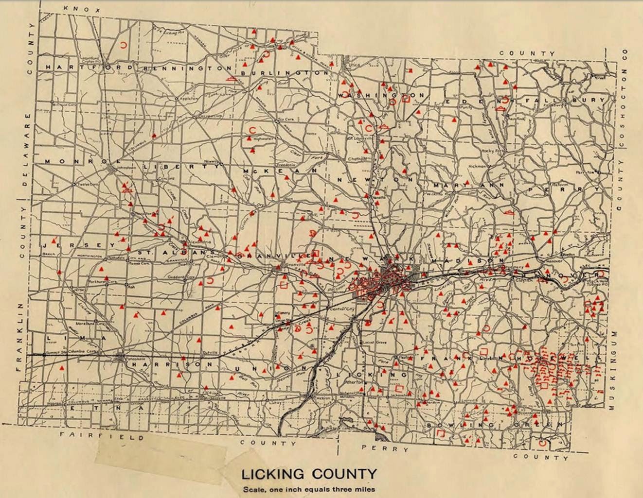
Licking County. Archaeological Atlas of Ohio. Page 45. Image Courtesy of the Ohio State University.

Cartographic Legend, Archaeological Atlas of Ohio. Image Courtesy of the Ohio State University.
"Licking County is one of the richest counties in the state from an archaeological viewpoint. Its importance lies in several directions. Not only foes it contain the greatest source of material used in the making of... flint implements -Flint Ridge- but also one of the finest examples of the complex type of earthworks, that known as the Newark works.... Thus it is seen that the county contains examples of all important classes of earthworks found in Ohio and is in itself typical of the state as a whole."


*Note: Please remember this source was published in 1914 and as such reflects information and views of its time.

Adams County
"The great "Serpent Mound" of Adams County is in many respects the most remarkable of Ohio's prehistoric monuments, and ranks among the greatest of the world's so-called effigy mounds... Adams county is rich in mounds and earthworks of the... peoples of Ohio, particularly along Brush creek and its tributaries and along the Ohio river."

For more information,
Visit:

Tuesday, October 7, 2014

My Dream Show by Candi Wesaw

My Dream Show by Candi Wesaw August 27 - December 8, 2014 Exhibit Postcard
August 27 - December 8, 2014.
 'Candi's drawings are from the heart, tapping on ancestral knowledge and raw emotion to bring forth pictures full of artistic skill and accurate detail that will make the viewer study them carefully and come away enlightened. Her ability to interpret text and ideas and turn them into visuals is unrivaled. She's a pleasure to work with and I recommend her highly.' 


Candi Wesaw is from Hartford, Michigan and a citizen
 of the Pokagon Band of Potawatomi Indian Nation.
She is deeply connected to her culture, heritage, and the arts.
 Ms. Wesaw works in multiple mediums and formats,
 including illustration, textiles, photography, and traditional native arts.
 She has also illustrated a series of children’s books about the Potawatomi,
& is motivated to share her talent with youngsters to promote mutual cultural understandings.

Artist Reception
 October 12th, 2014.
7 PM.
Free and open to the public.
Refreshments will be served.


For more information, contact Dr. John Low, JD, Ph.D., Assistant Professor, 

Department of Comparative Studies at low.89@osu.edu .


For more information about Ms. Wesaw, 
Visit: 

We hope to see you there!

Monday, October 6, 2014

Ohio's Indians: Past and Present on "All Sides with Ann Fisher"

All Sides with Ann Fisher, WOSU 89.7 npr news

September 22, 2014.
George Ironstack, assistant director of the Myaamia Center at Miami University, and Dr. Brad Lepper, curator of archaeology for Ohio History Connection are guests on All Sides with Ann Fisher. This hour long podcast is focused toward exploring the impact of Ohio's tribes both ancient and modern.

To listen to the entire podcast, click here.

Friday, October 3, 2014

Haudenosaunee- United States Treaty of 1794 Comes to the Museum

 Faithkeeper of the Turtle Clan of the Onondaga Nation of the Haudenosaunee Confederacy Oren Lyons, PhD; Tadodaho of the Haudenosaunee Confederacy Chief Sidney Hill; Suzan Harjo (Cheyenne and Hodulgee Muscogee), guest curator of Nation to Nation; Kevin Gover (Pawnee), director of the National Museum of the American Indian; and Jim Gardner, executive for Legislative Archives, Presidential Programs, and Museum Programs at the National Archives, unveil the Treaty of Canandaigua of 1794, on loan to the museum. Image Courtesy of the National Museum of the American Indian Blog.
 Faithkeeper of the Turtle Clan of the Onondaga Nation of the Haudenosaunee Confederacy Oren Lyons, PhD; Tadodaho of the Haudenosaunee Confederacy Chief Sidney Hill; Suzan Harjo (Cheyenne and Hodulgee Muscogee), guest curator of Nation to Nation; Kevin Gover (Pawnee), director of the National Museum of the American Indian; and Jim Gardner, executive for Legislative Archives, Presidential Programs, and Museum Programs at the National Archives, unveil the Treaty of Canandaigua of 1794, on loan to the museum.
Image Courtesy of the Kevin Wolf and the National Museum of the American Indian Blog.
September 11, 2014.
The National Museum of the American Indian Blog has written an interesting post about the recent loan of the 1794 Treaty with the Six Nations for the exhibition of Nation to Nation: Treaties Between the United States and American Indian Nations. This treaty is "one of the earliest negotiated between Native Americans and the U.S. government under the Constitution".

"The two parties wished to confirm the peace between them and to secure their respective interests. Working together, the Six Nations—Seneca, Cayuga, Onondaga, Oneida, Mohawk, and Tuscarora—sought to recover lands in New York State they had lost to the United States following the Revolutionary War. The United States wanted Native lands in Ohio and assurances that the Haudenosaunee would not ally themselves with the Ohio tribes against the U.S. Army. "

To read the full post, click here.


For more information,
Visit:

Thursday, October 2, 2014

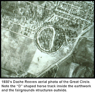
Newark's Great Circle History

The Ohio History Connection Archaeology Blog has posted a series of posts on the past of the Newark Earthworks by Bill Pickard and Brad Lepper. They not only include not only a basic overview of the recent history of the earthworks' preservation but also include photos of primary historical sources.

The Newark Earthworks as Licking County's Fairgrounds. Image Courtesy of The Ohio History Connection Archaeology Blog.
The Newark Earthworks as Licking County's Fairgrounds.
Image Courtesy of The Ohio History Connection Archaeology Blog.
 November 18, 2008

"in the time since the city of Newark was founded in 1802, the earthworks have undergone a number of significant changes. Many of the mounds and smaller earthworks disappeared literally overnight as Newark expanded and further progress came to that part of Licking County, in the form of the canal system followed by the railroad and finally an improved highway system. It wasn’t so long until what was once an absolute marvel of engineering, construction and human endeavor was reduced to just its two largest elements, the Great Circle and its cross-town neighbor, the conjoined Observatory Circle and Octagon at Octagon Earthworks State Memorial. "

To read the full post, click here.


Image Courtesy of the Ohio History Connection Archaeology Blog.

October 20, 2009

"Well into the 20th century the Great Circle continued to see its share of use and abuse as a county fairgrounds and finally as an amusement park and I have been told that as late as 1932 the race track remained a favored venue for motorcycle racing. It was about time to treat the Great Circle with the respect due such a magnificent example of human endeavor."
-Bill Pickard, The Ohio History Connection Archaeology Blog.

To read the full post, click here.

Licking County Fairground buildings. Civilian Conservation Corps photograph, May 1934. Image Courtesy of Ohio Memory and the Ohio History Connection Archaeology Blog.
Licking County Fairground buildings. Civilian Conservation Corps photograph, May 1934.
Image Courtesy of Ohio Memory and the Ohio History Connection Archaeology Blog.
September 1, 2014.

"In 1933, the Licking County Commissioners deeded the Great Circle to the Ohio History Connection. By then, the fair grounds attractions had become objectionable features and with help from the Civilian Conservation Corps(CCC) we removed the last above-ground remnants of the fairgrounds and restored the earthworks to our best approximation of their original condition."

To read the full post, click here.


For more information, 
Visit: